July 14, 2011

#Stuxnet lessons for Urban Planning in Conflict. 1 of 2


In July 2010, the Stuxnet computer worm surfaced as a powerful destructive force that targeted specific industrial systems.  While most computer attacks are constructed to exploit the weaknesses of Microsoft systems, Stuxnet is unique because it functioned on 3 different layers.  It used Windows OS in the intial stage and then  transfered to another operating system, Siemens WinCC or PCS7. After installing itself on WinCC, it then installed itself on a PLC device (Programmable Logic Controller).  PLC's are basically small computers designed to operate industrial equipment and generally do not receive commands through a network.  Although all the details of Stuxnet are not determined, it is clear that it sought PLC's with the intent to control frequency converters and thus modify the speed of mechanical motors. Stuxnet also relayed false information to monitoring devices so that everything appeared to function as normal.  Upon discovery many feared that Stuxnet had the potential to bring global industry to a halt. 

Impending doom is never appreciated, yet in the case of Stuxnet, it was also quite unlikely. Remarkably, Stuxnet only affects machines with particular characteristics and that do specific tasks and there are few industries in the world that contain such characteristics.  It is believed that Stuxnet was created by a western government to undermine Iranian attempts to create nuclear materials for combat purposes.  Some suspect Israel, others the United States, yet the designer of of the virus is completely indeterminable.  

What is apparent however, is that the creator had expansive resources, a specific objective, and was faced with significant limitations.  If destruction or at least the tampering with Iran's nuclear facilities was the intended objective, the designer had to create an streamlined yet sophisticated tool to modify the mechanics of uranium enrichment.  Most importantly, this enrichment system is not accessible online, and attack had to be introduced at the periphery and then distributed through continued USB use and internal networks.  The virus likely reached its final objective, considering Iran began having difficulty in May 2009 with operational centrifuges (IFPM Report, 17).  Stuxnet was only noticed a full year later.  Roughly 1/5 of their centrifuges were destroyed.

Stuxnet, Urban Planning and Conflict Stabilization
Urban interventions confront a variety of constraints and limitations, such as limited budgets, poor communication and disruption among social groups, and lack of capacity for implementation.  At all times, urban planning also has to straddle the void between top-down 'expert' interests and the will of the 'bottom-up' community.  No matter the situation, Urban Planners nearly always use the same problem solving strategies.  Planners consistently rely upon a Logical Framework Approach or combine this with Participatory Action strategies.  These strategies are typically sufficient, yet there are many times in which the obstacles are too large or the network of contributing factors is too complex.


I recall an architect who constructed IDP shelters in Somalia. She said that she "didn't bother asking people what they need or want because it is a waste of time, she just gave them the best solution" and when I asked about that solution, the area was first bulldozed of all surviving vegetation, drawn into a grid and an Australian engineer introduced a concept for mud brick houses.  Local acts of violence escalated shortly after as no one had shade from the hot desert sun and small fights between frustrated youth grew into tribal combat. When the houses went up everyone was relieved until families began to die from collapsing structures. Of course the architect wasn't around to witness the consequences of her decisions as she had already moved on to other projects.  Clearly, the most direct and expert-oriented solution is not necessarily the best solution.

Looking at Stuxnet, I see a product that imitates a perfectly constructed urban planning intervention. Severely constrained by technology, geography, and security, destruction at the Nantez nuclear production plant required a clever, unorthodox design and  streamlined  precision.  The designers had to work as a team to mobilize dispersed resources, to consolidate those resources in a fashion that could penetrate a complex network and accomplish a specific objective with re-percussive impact.  Although Stuxnet was introduced at a single point, the fluidity of its design allowed simultaneous access to multiple communication networks, applying to those that fit the targeted criteria and skipping others. At its end point, it made only minor tweaks to an already existing process, barely noticeable to the population yet large scale in consequence.  How can Urban Planning function in a similar manner? Planning interventions within conflict could greatly benefit from the lessons of Stuxnet.  

July 13, 2011

#Somalia: Hot, Dry and Dangerous


The last few days in Somalia have been like any other - hot, dry, and dangerous.   The aggressive drought has displaced thousands, crowding the Dadaab camps and bringing the ongoing humanitarian crisis to an unprecedented level.  At the same time, it is clear that the US government is slowly focusing more attention on the region, recognizing the increasing threat that this nation poses to international stability.  Here is a quick overview of current conditions.

Drought
Drought (red) concentrated in South
The drought has continued to devastate Somalia to such an extent that al Shabaab has even welcomed aid agencies to return to the region.  While agencies such as WFP are mobilizing, it doesn't appear that everyone got the message, as some Shabaab fighters have continued to capture aid workers.  The question remains if Shabaab will continue to have the significant power to administer the region, as head commander Ahmed Abdi Godane discussed problems the group is facing on a Shabaab friendly radio station.

The current dry spell is far worse than previous years, such as th early 1990s, as there is no longer any alternative infrastructure to absorb the catastrophe.  Although the western regions have seen a little rainfall, the Juba valley remains dry. While international agencies scramble for access, the TFG finds it has too little resources to make an impact, evidenced by TFG soldiers offering their own paychecks over to afflictedfamilies. While over 350,000 displaced people seek protection in the Dadaab refugee camps, the population will likely continue to increase as nearly 75% of the nations harvest is expected to fail.

US Intervention
CIA conducting interrogations in Somalia.  As shown within a recent congressional hearing, the US Government believes to officially recognize the  strengthening  regional links between Somali militants and al Qaeda and the devastation of the nation is globally permeating.  he CIA have been increasing their presence and interventions in the region, most recently training TFG soldiers in counterterrorism strategies and intelligence collection.  Many of the interrogation practices are supposedly undertaken in an airplane hanger adjacent to the airport and in the basement of the TFG's National Security Administration.  The NSA basement has a long history of abuse and torture, infamously known as godka, the hole, while under the rain of dictator Siyad Barre.  

Al Shabaab
Moderate pro-government militant group Ahulu Sunna Wal Jamaa (ASWJ) has elected a new leader, Sheikh Aydarus Sheikh Ahmed Siid Warsame, and vowed to fight against al-Shabaab in Gedo region.  The former leader was killed in an ambush by Shabaab fighters. 

In related news (ambushed convoys), it was confirmed that the helicopter attack near Kismayo was actually a drone attack upon an al-Shabaab convoy, targeting and killing on of the top leaders, Ibrahim al Afghani.

Media
Below is a brief video from BBC.  The story is covers the general state of conditions but the footage is quite strong.  The beginning features a spectacular flyover of Dadaab.


July 10, 2011

II of II: Space, Informal Sector, and Central Place Theory


Location and land use have been long understood as key to functional economies, ever since the days of David Ricardo who described land as an inelastic factor in economic production.  Later, Christallar's Central Place Theory was able to advance the similar concepts, recognizing that market prices fluctuate according not only to demand, but also according to location and logistics, and therefore human settlements are spatially distributed according to the range of their products and the value (order) of exported goods.  Yet if Central Place Theory fully explained the 'why' and 'where' of human settlements, all cities, towns and villages would be distributed at equitable distances.  This is not possible because a collection of other factors determine the location and size of human settlements.  Although the list is not exhaustive, some of the most important factors are the following in no particular order:

1. Transportation and Communication Technology - varies by type of transport, carrying capacity of transport, speed (affected by density of traffic), and quality of transit/communication corridors.
Example: Although transportation and communication function differently, I would argue that both function toward the same mutual objective and that the value of productivity for one will inform the value of the other.  Access to paved highways, dirt roads, footpaths, water transport, airways, supply chains, phone networks, mail delivery, internet access are similar in economic and social gains.  The distinction is located not so much in their productivity, but rather the productivity over time.

2. Availability and supply of natural resources 
Example: What raw resources are available for food, repairing goods and automobiles, and construction such as water, lumber, pasture space and high yield soil ?

3. Availability and supply of processed resources
Example: What value-added resources are available for food, repairing goods and automobiles, and construction such as gasoline, steel, and pharmaceuticals ?

3. Concentration of social groups and cultural expectations for housing, land use, and production
Example: Rural households in India have traditionally subdivided land among the children of the family at adulthood, yet the continual subdivision eventually creates indeterminate zones of urbanization, leading to long stretches of 'urban-like' settlement along transit corridors between towns.  As the population rises the lines between rural and urban are less clear and the basis of settlement is rooted in sheer availability rather than utility/adaptability.

4. Location and efficiency of disposal systems for waste and excess resources
Example: Excrement, refuse, and drainage during rainy seasons through either structural intervention or permeability of soil.

5. Ratio of resources that contribute to security (scaled from regional such as defense capacities of natural terrain to family unit such as housing design) vs. hostility and expectations of outside threats.  
Example: Location of town at a mountaintop with farmland in the valley supports water flow to the crops but also creates a defensible position.

These factors interact in a give and take arrangement to facilitate the establishment and spatial determination of settlements.  For example, where ever two different systems of transportation intersect (such as river and an arterial road), one can always locate a settlement often occupied in proportion to the productivity of the transit routes.  Thus a city will always be located at intersection of a major highway and a large river while a small town will be found at the intersection of lesser used routes. Notably the significance of each of the above conditions are directly or indirectly economically determined.

Informal Sector and Urban Form
In the 1960's and 1970's the International Labor Organization promoted the concept of the informal economy so as to explain and measure the role of markets that are outside government regulation and institutional recognition.  Of course the term is rife with complication, considering the vast size and activity of these markets and the frequent confusion of informal activity with illegal.  Arguably, for most of the world's population, the informal marketplace is simply a matter of daily life and survival, and the workings of the formal economy are merely the actions of an inaccessible or poorly structured distant bureaucracies.  Due to the binary dissection of the global market, the immense overlap of formal and informal markets is poorly measured while the opportunities for valuation in local assets remains limited (such as through the failure of formal economies to recognize improved housing and settlement consolidation where no 'formal' terms of property ownership are established).  In many ways, the conception of markets as informal undermines the greater economy by failing to recognize the dynamism of productive, informal assets.

Location of Informal Settlements in Tirana Albania
Working both within and outside of formal frameworks, the informal sector modifies and determines urban form in a slightly different fashion than the rigid conception of Central Place theory would dictate. Historically, the wealthiest populations are located at the center of the settlement, where the most resources and logistical corridors overlap.  The concentration of wealth in the center promotes urban design and planning initiatives to maximize resources by creating a grid-like plan or some similar design.  The formalization of interior space consequently marginalizes spaces of production (preference is given to spaces of exchange, raising their value and consolidating the city center as a space of wealth) and the impoverished, leaving only the outskirts of the settlement for the poor along with industrial spaces and thus the phrase, "lives on the other side of the tracks." 

Bangalore Aerial View 
Bangalore Supply Corridors and Central Place Polygon
In other instances, usually when the concentration of wealth and division between social classes is not as severe, one could argue that informal activity could determine the regional establishment of settlements more akin to the demands of Christallar's assumptions as the informal economy is greatly determined by the principal of least effort.  Patterns in land use are going to be situated as closely together as possible to maximize resources at the lowest cost.  Thus clusters evolve, wherein similar businesses are all located in the same area and often adjacent to suppliers. 

As consequence of the clusters, even a single settlement that is seemingly chaotic can be quickly subdivided into land use types, supply lines, and in consequence, one can make inferences about the social composition of the neighborhood, such as local priorities and values. For example, the city of Bangalore is quickly deconstructed into something manageable.  Notably, the city is laid out as a collection of concentric polygons, not too far off from Christallar's hypothesis.

July 6, 2011

Part I of II: Central Place Theory and Informal Economies


In 1933 Walter Christaller made a ground breaking contribution to the understanding of economic geography with the founding of Central Place Theory.  This theory seeks to explain the spatial structure, scale, and quantity of urban settlements as an inter-connected system.   Determined by studying settlements in southern Germany, Christaller noted that many settlements of similar scale and composition were equidistant from one another.  While his model is founded upon a collection of unrealistic assumptions such as the expectation of markets to function in equilibrium and for transportation between cities to have equal costs, he nonetheless established some valid conclusions.

Christaller determined that each human settlement functions as a central location to provide services and goods from the core to its peripheral threshold.  The distance to that periphery will very for the quality of goods, where as common place items, items of the lower order such as common produce, have a smaller geographic sphere of influence and high order goods - gourmet items -  maintain value across greater distances.  At a certain point, the value of the item reaches a threshold, where it is no longer to the advantage of the consumer to spend time/money to travel the distance and acquire that item.  This  process is also observable within a previous post, wherein I discussed the presence of Coca-Cola as a socio-cultural and economic indicator.  The cost of Coke is high in the center of the city (because of the stronger markets) and as one travels into the hinterland the cost drops until a threshold is crossed and the price begins to escalate due to rarity.  In America or Europe, the threshold would overlap with another marketplace and the cost remains constant.  However in many developing countries, the market reaches its threshold and the product is simply no longer available.


Central Place Theory 4x
Although a product's area of influence is assumably circular from the point of origin, Christaller modified the model as the juxtaposition of circled regions would leave gaps with no service.  By adapting a hexagon, one is able to adjust the scale of the model, isolating single settlements and zooming out to identify how settlements of higher order (large cities such as Chicago, New York, London, Paris) are few and far between, interwoven and interdependent economic landscape. The distribution of markets and market centers reveals that each city center shares 1/3 the market of the adjacent market of equal scale (the K=3 principle); the market of the highest order dominates all adjacent markets, and this dominance promotes efficient transportation of goods by working from a central administrative hub (the K=4 and K=7 principles).


Yet how does this same concept apply to alternative human settlements?

Presumably other human settlements function in a similar manner.  The same geometric spatial pattern may emerge among administrative centers or military bases while an inversion of central place theory also highlights urban settlements of tactical significance within a military operation.   Administrative centers and economic hubs may take multiple forms, and it is no surprise that the changing of government regimes, political power, ethnic composition and market transitions often witness the imposition of new systems on top of the previous systems.  Classic examples may be found in ancient cities such as Jerusalem, Rome, and Cairo, however more immediate examples are easily found.  Of course the act is typically symbolic, to display the replacement of power and the dominance of the ruler.  However the process is just as often logistical, as these cities frequently maintain economic advantages.

Recently in Afghanistan, one can find a similar example as an al-Queada militant training camp now functions has a rural development hub, while the primary Counterinsurgency strategy of NATO and US Forces in the nation has consisted of establishing secure administrative centers for reconstruction and development.   In contrast, al-Queda linked militants in Yemen have targeted military bases throughout the south of country at nearly equidistant locations from one another.   Both NATO and the militants are ultimately attempting to do the same thing, but clearly different reasons.

As Central Place can provide insight into the economic sub-structure of a settlement, it also provides tools to illuminate gaps within service provision, governance, and economic markets.

What is unclear however, is the  the role of Central Place Theory within Informal Economies. As informal economies dominate the global south, and illicit economies often function in a parallel or overlapping nature to support militarization and criminal networks, it is unclear how these less measurable systems may comply or conflict with Central Place Theory.  Demand for weapons, drugs, and sex workers is subject to economic constraints, yet these goods are also traded by complex means, often taking great effort to avoid formal institutions and legal authorities.

Please return for Part II of Central Place Theory and the Urban Economy.

July 2, 2011

Planning and Conflict in #Dadaab Refugee Camp: Land Use Law, Zoning Regulations


Violence erupted at Dagahaley camp (aerial view above), in the Dadaab Refugee Camps this week.  Rioting was incited when Kenyan police attempted to demolish a Mosque and small businesses.   According to UNOCHA, "Rioting broke out when police sought to disperse a crowd that was protesting an attempt to demolish illegal structures around a food distribution point. Teargas was used, and later live gunshot. Our information is that two refugees were killed and around a dozen injured."

The event raises several questions: for structures to be illegal, what sort of land use laws are in place within the camp? Who determines the legality of these structures?  How does the process work?

As it was Kenyan police attempting to demolish the site, we can assume that the Kenyan government serves as the enforcement body.  Other reports site that the demolition squad was acting on behalf of refugee aid agency that requested the demolition.  The same report cites the Director of Refugee Affairs as having requested the demolition, which is more likely since no aid agency is going to have the ability to use Kenyan Police.  Not to mention, aid agencies are the guest of the host nation, and do not have the ability to declare structures as "illegal" although the state may request the agency to curtail illegal processes.

A question comes to mind however, as the circumstance suggests some sort of zoning law and legal structure to oversee the regulation of land use within Dadaab.  There are planning processes undertaken by UNHCR and the Ministry of Refugee Affairs, as bore-holes, market spaces, and housing blocks are planned within each refugee camp.  In addition, efforts have been taken to relocate many of the settled refugees who occupy low lying land are subject to flooding.  The town of Dadaab and the surrounding camps however do feature a publicly accessible centralized plan nor is there a specific planning office to manage such issues.

In the meanwhile, it is expected that Dadaab will reach a total population of 450,000 by the end of 2011.  Other cities with about the same population size are Cleveland Ohio, New Orleans Louisianna, and Dublin Ireland - yet those cities all have economic infrastructure, transportation, and clean water.  In the meanwhile, thousands of Somalis are stuck living outside the camps, subject to harsh conditions, no water, no food, and violence.  It has been reported that men are working in shifts to guard their families from hyena attacks.  One of the major problems is that the UN refugee registration center is several days journey from the camps, positioning refugees needlessly in the way of danger.

The host government maintains its grip on the land, as the camps are beyond capacity with 370,000 refugees in need of protection. In the meanwhile the extension camp IFO 2, constructed by the Norwegian Refugee Council in 2007 remains mostly empty as the Kenyan Government refuses access to the camp and it remains nonoperational although several ngos are ready to implement services.

June 29, 2011

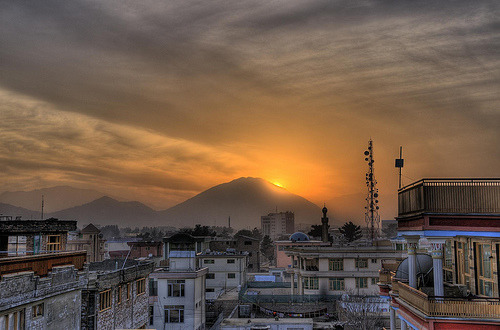
With my eyes fixed on Kabul


*Posted 6/29/11, Edited and Re-posted 6/30/11


As I prepare to relocate to Kabul in the coming months, watching the chaos at the Intercontinental Hotel yesterday made me physically ill.  Simultaneously I felt angry and frustrated.  Part of me was questioning the resolve to go to Kabul and the other part of me felt only more determined to get there.  I don't go looking for fires in the world as much as I look for ways to extinguish them, and watching the tragedy unfold, I felt as if the fire just got a great deal bigger.

It is for the very fact that I want to see a world of peace and justice, where no one must suffer needlessly, that I support any institution- be it nations, armies, corporations, or otherwise - who dedicate their resources to bring education, capital, and legal systems into the corners of the world.  Terrorism and aggression byproducts of global injustice, a consequence of international systems having marginalized vast regions of the globe, creating pockets of chaos, poverty, and despair.  As long as the world contains vast populations of alienated, frustrated youth who are denied a better future due to illiteracy, misinformation, and extreme poverty, tragedy will continue to touch our lives.  

Perhaps the avoidance of such ungoverned spaces would have been excusable in the past, but in a global era, the chaos of these regions will continue to permeate into the world.  Avoided regions such as Somalia affect the world everyday, evident by the 8.3 Billion Dollars lost to piracy in 2010, a metric that does not reflect the loss of innocent life or the displacement of millions of people.  Without continued effort to stabilize and facilitate an educated peace, will  today's Afghanistan, Yemen, Pakistan or elsewhere be any different?  

We can choose to intervene and invest in the well-being of humanity, to spread education, improved housing, access to clean water and opportunities for social mobility, or we can continue to marginalize populations.  The construction of economic barriers will not solve problems by removing them from sight.  In contrast, it will only give reason for people climb them, and when that is not possible because the wall has grown too high, it is only too be expected that those on the other side will fight to break the wall down.

I am saddened to see the lost of life from yesterday's attacks, and naturally fearful when I look at the problems facing me down the road.  Such incidents shock the conscious and shake me at the core.  My job is not to solve such problems, to "save the world" or bring peace and justice.  My job is to supply straight forward solutions to complex problems, very much in the way that a mechanic fixes a car or a technician repairs a computer.  The only difference is that I have to work with communities.  It is unfortunate that solving these problems - such as providing education and technical training to expand economic markets and reduce poverty - must confront hostility by an isolated and active minority.  Yet it is more unfortunate that so few are contributing solutions. 

It is understandable that not everyone has the ability to directly contribute to solving such problems.  Yet everyone has an ability to contribute in some particular fashion.  One place to start is with a modest donation to an aid agency.  I suggest MSF, as they take on  the greatest humanitarian challenges in the world and do not have any political support, operating entirely by private donations. More importantly, they are arguably the one of the best agencies, and are a leader in their field. Click Here to Make a Donation Online.  For now, I will  continue to measure the conditions in which I need to work in the future, and will continue to calculate the ratio of risk I am willing to confront for a each particular job.  While I continue to determine the fine balance of personal ability vs personal risk, I hope that others can at least make a small contribution to support those who do the same, and often in far more dangerous circumstances.

June 26, 2011

Reading #Conflict in the Urban Terrain of Kismayo, #Somalia


Recent reports from Somalia have described a helicopter attack on al-Shabaab fighters near Kismayo.  Originally reporting the death of two fighters, it now appears that 15 died in the missile attack.  Kismayo is an al-Shabaab stronghold where a great deal of fighting has taken place. 

A quick look at the city on Google Images reveals a large section of the city blackened by explosions and fires.  The pattern of scorched buildings is consistent with the major transportation corridors highlighted in red. As the conflict in Somalia is highly mobile and fast moving, gains are established by taking hold of the roadways, thereby assuming control of the neighborhoods pinned between roads.

If one isolates the individual locations of attack, a subtle collection of patterns emerge.  The largest areas of combat often take place at transportation intersections.  This provides  the largest variety of logistical and operational  input/outputs, such as improved range of vision and horizontal expansion of battle space.

Yet further analysis also reveals two primary bands of conflict.  Both bands are curvilenear, suggesting 2-3 primary points of entry for troops.  The band on the left, situated on city limits, shows on large point of conflict followed by a series of smaller points.  Either the conflict began at a fever pitch and tapered off, or it built to a climax in the first band.

As the conflict continued and forces swept into the city, the second band emerged. They traveled most likely from the lower corridor which contains clear horizontal roadways and is less entangled in the labyrinth of smaller, internal side-streets.  Al Shabaab would have likely traveled northward, continuing to take advantage of major transportation arteries and as the land came under their control, the intensity of conflict would subside.

June 21, 2011

#Kabul, #Afghanistan: #Skateboarding toward the future


More often than not, international development is pursued as a purely economic process.  Roads must be built, banks must be strengthened, housing improved, and health care should be made accessible.  Yet the simple construction of institutions, the provision of infrastructure, and the implementation of social programming is not enough to solve all social problems because social problems are complex. It is common wisdom that these complex problems can only be solved internally, within the community,  yet the community generally lacks the means to to action.  Conversely, aid agencies frequently advertise for specialists in "capacity building" and yet within the job descriptions, the term "capacity" remains consistently vague.   While capacity is best defined as an internal ability to pursue and implement active change, when the workings of communities are merged with capacity, the concept bubble stretches to a breaking point.  The scale of the problem remains too much for the solution.  Sometimes something else is needed, a strategy that is less direct than teaching job skills or creating new markets.

While in Cairo, I witnessed the transformative power  of that simple social programming can have within the lives of youth who must grow up in poverty and who lack opportunities for personal advancement.  Viable social programming, such as sports, music, or even the provision of a space to play, can transform a child's life.  Certainly these things alone cannot remove the frustrations of poverty or the pains of social alienation, nor can these things provide the same concrete tools for personal advancement as education and job training.  Yet these sorts of programs create opportunities for confidence and self esteem, provide opportunities to for children to communicate and express themselves.  Self expression is easily undervalued because its role is immeasurable, but little imagination is necessary to recognize that a confident child will find more success in life than one who is alienated and unhappy.  Even where opportunities are limited, those with confidence and pride will creatively seek solutions, believing that solutions are possible.

This evening I discovered the brief documentary Skateistan: To Live and Skate Kabul.  This film shows the work of an ngo to bring skate boarding to youth in Kabul.  It shows how a nice space for play, how basic access to safety and fun may wield a transformative power.   The film reveals how something as simple as skateboarding can dramatic shape an individual's life.  Now imagine, if a child impacted by something as simple as skateboard had the chance to go to school, to drink clean water, and to walk down the street without fear.  Apply the same concept to hundreds, perhaps thousands, of children in a city like Kabul and the concept of capacity becomes strikingly clear.  Suddenly the future isn't so bleak.

Kenya's Superhighway


A super-highway through Kenya is under construction, complimented by the development of a new trucking industry and ocean port.  Chinese investment in the region is spurring such projects, leading the construction of the Thika Road. By expanding an existing route, this development will connect Kenya's local economy with the surrounding region, ease traffic, and facilitate the movement of roughly 80 million people.

The road construction includes the expansion of existing roadways to interconnect the new project with preexisting infrastructure, improving access to universities, cinemas, and the national museum.   It also includes flyovers, underpasses, and a full drainage assemblage. Construction hasn't been entirely smooth, as tensions over hiring processes have led to large scale protests. Many land owners were also dissatisfied to lose their land to the project. The project will take three years and three construction companies to complete the project, but will have large scale impact on the regional economy.

Economist Jeffrey Sachs once stated that one of the greatest projects our world could pursue to overcome poverty is to build an efficient transportation route throughout East Africa, "rather than a two-lane, broken-down road," that presently serves as the only transit corridor from Mombasa to Burundi.  Perhaps the Thika Road expansion is will lead to other such projects, and Sachs' vision will become a reality.

June 20, 2011

Reporting the Frontline of Conflict in Mogadishu

A lighthouse in Mogadishu destroyed by war. National Geographic.
After monitoring the conflict in Somalia for several years, I can attest to the limited flow of information from the region.  Insufficient information results in insufficient analysis and Somalia is subject to the worst circumstance of all - insufficient concern.  While the conflict rages with global implications, the lack of journalism and knowledge on the region precipitates a disproportionate lack of conviction to intervene and assist. 


Today I found a video briefly covering the frontline of the conflict in Mogadishu.  It is not often that one has the opportunity to watch video footage of the central conflict in Somalia.  It is not possible to embed the flash video from the BBC's website, so it is necessary to use the following link [Somalia].  Given the subject matter, I thought I would share with readers some of the other common media sources on Somalia.


New York Times resource page on Somali [LINK]
The NYT page is frequently updated with AP stories and independent NYT journalism, however the technical references such as their 'Experts' section is strongly outdated.  


IRIN Humanitarian News Somalia Page [LINK]
The IRIN site is a major source for news on the region, and is comprehensively connected to other UN-related organizations such as OCHA, so it tends to have a focus on development and displacement issues.  I do wish more maps were available in addition to technical data, yet I do appreciate the constant updates.


Hiiraan Online [Somalia News Site]
This Somali news source is frequently updated and closest to the source, but also is difficult to navigate and not easy to understand.  Sometimes the journalism is also not of a very high standard, the news is provided at a variety of scale - with pieces focusing on anything between specific urban issues and broader concerns within the Somali Diaspora.  Much of it is written in Soomaali language, but there is enough work in English to maintain its value.


Somalia Report [LINK]
I just recently discovered this site and I absolutely love it.  It only hires local journalists and constantly provides thorough updates on recent events concerning piracy, militant groups, and political leaders.  They also provide an email subscription service.

Urban Planning in Conflict

Kabul, Afghanistan

I haven't updated this blog for awhile, although daily updates can be found at The Humanitarian Terrain.  The next couple months will continue to have a low rate of posts, however in August I will have far more to write about as I begin my new position in Kabul, Afghanistan.  For the present are some small news blurbs concerning urban development issues in regions of interest.

UNHABIT releases Charter of Values [LINK].  In line with contemporary trends in economic and physical planning, UNHABITAT has required ongoing partnerships with private agencies to facilitate project implementation.  To encourage a strengthened relationship that remains centered on UNHABITAT priorities within the private sector, the agency as created a series of guidelines to frame future partnerships.

New Model on Evolution of Urban Settlements [LINK].  By merging an expansive study of regional linguistic structures and local political organization in South East Asia, scientists have advanced a theory on the rise and collapse of past civilizations, wherein those that advanced the most quickly became more vulnerable and prone to sudden collapse.


Upcoming Conference on Building Resilience [LINK]. Heritance Kandalama, Sri Lanka July 19-21. Interdisciplinary approaches to disaster risk reduction and sustainable urban development.


Brief interview with Somali Archaeologist Sada Mire [LINK].  Although initially displaced by the ongoing conflicts of Somalia, Sada returned from England's University CollegeLondon to discover prehistoric rock-sites in the northern province of Somaliland.

Approval for new Egyptian Science Research City [LINK]. The ruling military in Egypt approved the planning and construction of a new urban development dedicated to technological research and scientific advancement. The campus will be situated on 300 acres near Sixth of October City.

No Rest in Somalia. Somalia premier quits, Danish Warship offers Kenya 24 captured pirates, 25 member of al-Shabaab surrender, while continued fighting displaces more residents...  [LINK].  In a desparate attempt to round up new recruits, insurgents have been visiting Madrasa's in central Somalia, looking for schools to stop teaching and offer children to join the insurgency [LINK]. 

How to Build Something from Nothing

Trying to explain my day job to the American Geographical Society at Geo2050. November 2015. Everyday I have to give someone a 15 secon...